


※ TriPriend app offers discounts and free vouchers for a variety of Seoul cafes, restaurants, and facilities.
To download TriPriend app, please click the banner below.


Hiking is an outdoor activity that involves walking through natural landscapes while appreciating the scenery.

You can enjoy a leisurely walk in nature along a flat path that features a variety of natural environments.

It would be wonderful if there were a well-maintained trail and stunning natural scenery.

Today, we'd like to introduce you to stunning hiking trails in Korea!

Let's begin😎


The Biryong Falls Nature Observation Trail, located in Seoraksan, offers a delightful experience of leisurely forest walks and stunning waterfalls. This relatively short and gentle trail is ideal for beginners, allowing for a round trip of approximately 2 hours. The path leading to Yukdam Falls is flat, enabling you to hike at a comfortable pace. As you cross Biryong Bridge, the soothing sound of flowing water begins, revealing the breathtaking view of the waterfall. To reach Biryong Falls, you must cross the exhilarating suspension bridge at Yukdam Falls, which you'll encounter first. If you have additional time, I highly recommend ascending to the Towangseong Falls Observatory. Towangseong Falls was opened to the public 45 years after being designated as a national cultural property. By climbing the stairs from Biryong Falls for about 30 minutes, you can enjoy the magnificent sight of Towangseong Falls from the observatory!

Course: Seoraksan Small Park – Yukdam Falls – Biryong Falls – Towangseong Falls Observatory Distance: 5.8km (Approximately 2 hours round trip)
Difficulty: ★☆☆


Jeju Olle Trail is a network of paths that connects the villages of Jeju Island. Comprising a total of 26 courses, the trail spans 425 km and showcases the natural beauty of Jeju. To enhance your experience, we recommend utilizing the Jeju Olle Guidebook or participating in the Stamp Tour for a more fulfilling journey along the trail. The Jeju Olle Trail is renowned for its stunning scenery and attracts many adventurers who aspire to complete it. Among the various courses, Course 5 is particularly recommended. At the starting point, you'll find the official Jeju Olle Information Center, which is ideal for obtaining course guidance or taking a brief rest. As you proceed, you'll encounter the Keuneong Coastal Scenic Spot, celebrated as one of the most beautiful coastal walking trails in Korea. The trail continues to Soesokkak, where freshwater and seawater converge. Throughout your journey, you can relish unique experiences, such as traversing lush forests, enjoying breathtaking ocean views, and marveling at the rocky cliffs formed by volcanic activity.
Course: Namwon Port – Keuneong Coastal Scenic Spot – Taeusgae – Wimi Camellia community – Secheon Port – Nupbille – Mangjangpo – Soesokkak Bridge
Distance: 13.4km (Approximately 4 – 5 hours round trip)
Difficulty: ★★☆


Miryang Arirang Trail, regarded as one of the finest walking trails in Miryang, features a route comprising three distinct courses. Course 1 offers an opportunity to explore the hidden culture and history of the city center, while Course 3 invites you to leisurely stroll along the banks of the Miryang River. Course 2, the most highly recommended, includes a hanok of exceptional architectural significance. This course leads you to the Historic House of the Son Clan, which you'll encounter immediately after passing the starting point, Miryang Hyanggyo. Among the various traditional and modern hanoks, Historic House of the Son Clan stands out as the oldest and largest, boasting a history of over 300 years, with its original structure remarkably well-preserved. Following your visit, you can delve into the history and culture of Miryang at the Miryang City Museum and take in the breathtaking views from the Chuhwasan Fortress. On your descent, be sure to stop by Chunghontab(Memorial Tower), a memorial honoring the soldiers from Miryang who lost their lives in the Korean War, as well as the Miryang Arirang Grand Park!
Course: Miryang Hyanggyo – Historic House of the Son Clan – Miryang City Museum – Miryang Beacon Mound – Chuhwasanseong Fortress – Chunghontab – Miryang Arirang Grand Park
Distance: 4.2km (Approximately 2 hours one way)
Difficulty: ★★☆


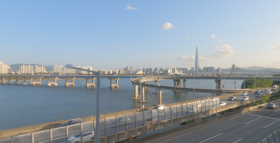


The Seoul Trail comprises 21 courses that span a total of 156.5 km around the Seoul. Its location in Seoul makes it easily accessible, allowing visitors to experience the rich stories of the city firsthand. Notably, the trail is predominantly flat, making it safe and comfortable for individuals of all fitness levels. Additionally, the trail offers stamp tours, providing a fun opportunity to collect stamps along the way. Among the 21 courses, the 6th course, which follows a historical path along the Hangang River, comes highly recommended. It's conveniently located near a subway station and is ideal for light hiking due to its gentle terrain. Starting at Gwangjin Bridge, you can stroll along Hangang Park and fully enjoy the scenic views of the Hangang River. Along the route, you'll pass the Amsa-dong Prehistoric Site, where remnants of pit houses from the Neolithic period, dating back to around 4000 BC, can be found. The journey culminates with a view of the Hangang River from Godeoksan Mountain, a gentle slope that rises approximately 86 m high!
Course: Gwangnaru Station – Gwangjin Bridge – Amsa Ecological Park – Amsa-dong Prehistoric Site – Godeoksan – Samteo Neighborhood Park – Myeongil Neighborhood Park
Distance: 9.3km (Approximately 3 hours one way)
Difficulty: ★☆☆


On the Jirisan Trail, you can immerse yourself in the essence of nature, local villages, history, and culture along the path that encircles Jirisan. With a total of 21 courses, you can explore the entire circumference of Jirisan, the 2nd highest mountain in Korea and one of the five most renowned mountains on the Korean Peninsula. The trail offers various difficulty levels, but the 2nd course, the Unbong-Inwol course, is particularly suitable for beginners. This section features flat terrain from Bukcheon Village to Gunhwa-dong, and even the most challenging part of this course consists of a gentle slope. The entire road of the trail is wide, making it ideal for walking with others. Additionally, you can enjoy stunning views of Jirisan’s northwestern ridge to the right and Baekdudaegan to the left. Throughout your journey, you'll encounter elements rich in culture and history, including the Hwangsan Battle Monument, the mecca of Korean traditional music, and the birthplace of Song Heung-rok!
Course: Bukcheon Village – Seorim Park – Shingi Village – Vision Village – Gunhwadong – Heungbugol Natural Recreation Forest – Wolpyeong Village – Guinwolgyo – Jirisan Trail Namwon Inwol Information Center
Distance: 9.9km (Approximately 4 hours one way)
Difficulty: ★☆☆


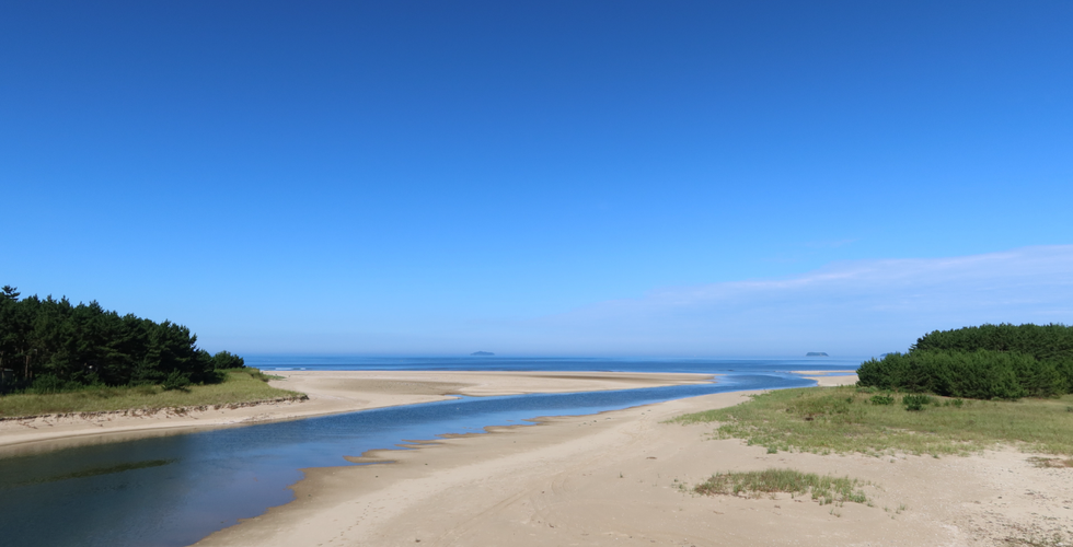


Taean Haebyeongil is a comfortable and safe trail along the Taean coast, offering stunning scenery and a unique coastal ecosystem. Among the 7 different courses, the 5th course, known as Noeul-gil(sunset road), provides breathtaking sunset views, particularly from Kkotji Beach, the final destination. Baeksajang Port, the starting point, is lined with restaurants where you can savor a variety of seafood and shellfish. After satisfying your appetite, let’s embark on our journey while enjoying the tranquility of a forest bath and the soothing sounds of the sea. There are numerous sights to behold, from Gijipo Beach and Changjeonggyo Bridge, which serve as habitats for rare flora and fauna as well as tidal flat creatures, to Duaegi Candlestick Rock, a unique formation shaped by maritime erosion. Finally, conclude your hike by watching the sunset at Kkotji Beach, renowned as one of the top three sunset spots along the West Sea!
Course: Baeksajang Port – Baeksajang Observatory – Gijipo Beach – Changjeonggyo Bridge – Duyeo Observatory – Batgae – Bangpo Beach – Bangpo Observatory – Bangpo Port – Kkotji Beach
Distance: 12km (Approximately 3 hours one way)
Difficulty: ★☆☆